GIS products
Getting an overview of the GIS product market is not easy. The annual GIS reports published by Harzer-Verlag at Intergeo are helpful here. The volume of 2018/2019 (Harzer, 2018) lists about 1000 short descriptions of GIS software and about 150 suppliers of GIS products in the German-speaking market alone. GIS product development has taken place over the last decades from universal GIS to desktop GIS to web GIS. While universal GIS were primarily usable by well-trained experts, Web GIS solutions are now found in many places and citizens can use them easily and without training. Web GIS solutions make it very easy to visualize and increasingly also analyze the geodata, which is now available in large quantities.
GIS product families include Server GIS, Desktop GIS, GIS Reader, GIS Viewer, mobile GIS, GIS services/ frameworks and GIS tools. Providers of such product families include Autodesk (AutoCAD-based products), Bentley (Bentley Map), ESRI Geoinformatics (ArcGIS family), GE Energy (Smallworld Core Spatial Technology), Intergraph (GeoMedia product family), MapInfo (MapInfoProfessional products). In recent years, a number of free and open source GIS products (e.g. Quantum GIS, OpenJump, gvSIG) have established themselves on the market. In addition, there are many individual GIS products or product components, e.g. in the area of application modules, which can be based on the previously mentioned product families or are established on the market as independent solutions.
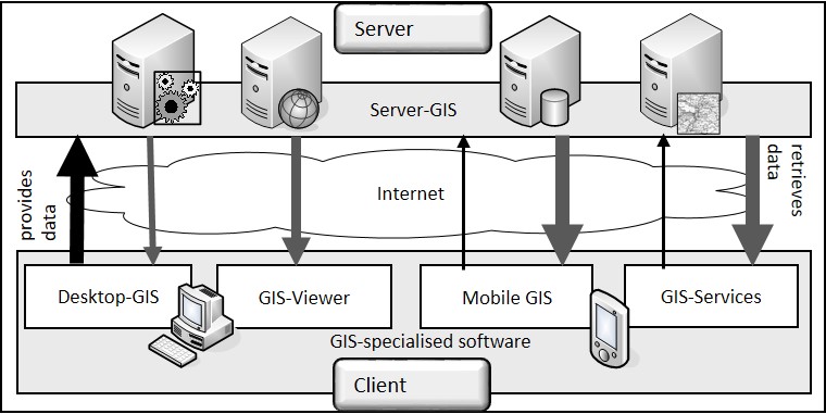
In larger production environments, e.g. in the public administration of a city, in a state environmental administration or at a large supply and disposal company, these different product components usually interact. The large amounts of data in the company are managed and made available on servers in the sense of a common backbone of the entire distributed system world (hosting). Usually, technically experienced users on Desktop GIS take care of the collection, qualification and processing of the various geodata, which are then viewed by many users via different GIS clients or used for simple queries. Mobile systems are increasingly supported (tablets, smartphones).

GIS products in interaction (according to Bill, 2010, p. 150)
In transactional applications, data can also be captured using GIS clients. The data collectors are mostly experts and use special collection applications and technologies. More recently, however, geodata has also been collected and made available voluntarily by interested citizens (Crowdsourcing, Citizen Science).
As already mentioned above, the development and application of GIS today includes commercial, free- and shareware as well as open source solutions. The limits are not always clear: commercial GIS also use free or open source components, and the providers of commercial GIS also provide some system components free of charge or as open source. Therefore, the decision to select and use a specific GIS must always be accompanied by precise investigations of the implied license conditions, extension and maintenance options and costs. Last but not least, the good usability of a GIS and the comprehensive and easily understandable system documentation (e.g. for system installation, application and training) play an important role in the product decision.
