| abbrevations | federal state | Source (URL) |
|---|---|---|
| BW | Baden-Württemberg | https://www.lgl-bw.de |
| BY | Bavaria | https://www.ldbv.bayern.de/ |
| BE | Berlin | https://fbinter.stadt-berlin.de/fb/ |
| BB | Brandenburg | https://www.lgl-bw.de |
| HB | Bremen | https://www.geo.bremen.de/ |
| HH | Hamburg | http://www.hamburg.de/bsw/geodaten/ |
| HE | Hesse | https://hvbg.hessen.de/ |
| MV | Mecklenburg-Western Pomerania | https://www.geoportal-mv.de/portal/ |
| NI | Lower Saxony | http://www.lgln.niedersachsen.de |
| NW | North Rhine-Westphalia | https://bezreg-koeln.nrw.de/brk_internet/geobasis/index.html |
| RP | Rhineland-Palatinate | https://lvermgeo.rlp.de/de/produkte/geotopografie |
| SL | Saarland | https://www.shop.lvgl.saarland.de/ |
| SN | Saxony | http://www.landesvermessung.sachsen.de/ |
| ST | Saxony-Anhalt | https://www.lvermgeo.sachsen-anhalt.de/ |
| SH | Schleswig-Holstein | https://schleswig-holstein.de/DE/Landesregierung/LVERMGEOSH/Service/geodatenService_node.html |
| TH | Thuringia | http://www.geoportal-th.de/de-de/ |
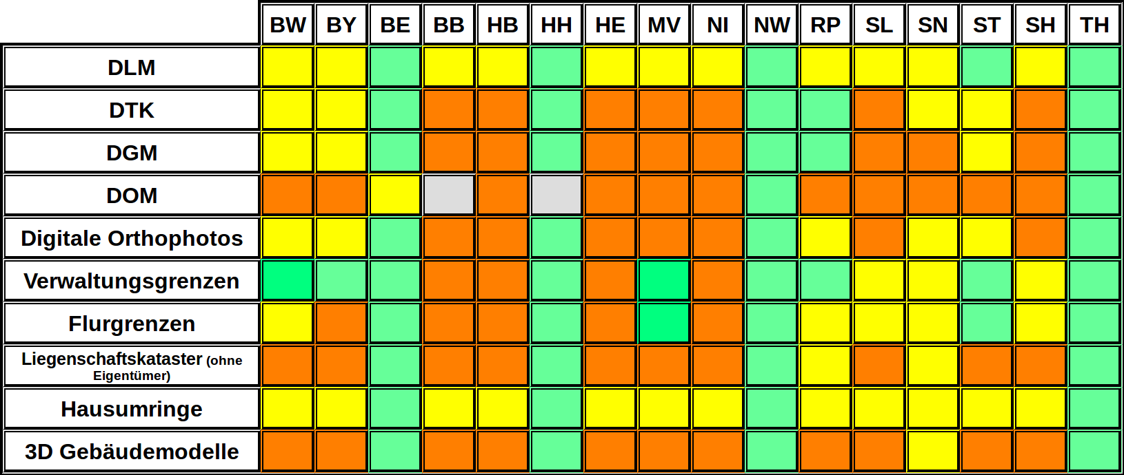
Availability of official geodata
In Germany, many of the federal geodata are available as Open Data. The federal states and many municipal administrations have made at least some geodata sets freely accessible, but the situation is heterogeneous. Extensive geodata sets, including high-resolution geodata (ALKIS, ATKIS, digital aerial photos, 3D city models ...), were made accessible by six federal states so far, important entry points in this context are:
- The Geoportal Berlin and Open Data Berlin
- Transparency Portal Hamburg and the Geoportal of the State of Hamburg
- Geoportal.NRW: The Geoportal of the State of North Rhine-Westphalia
- Geoportal-Th: Open Geodata portal of Thuringia
- Open Data Sachsen: Open Data Portal of Saxonia
- OpenGeodata.Brandenburg and Geobroker provide basic and thematic data of Brandenburg
Less comprehensive sources of basic geodata are available for Baden-Württemberg among others, see table below.
In Austria, the digital administration map basemap.at is the most widely used Open Data product of Austrian authorities according to the statistics of the national data portal and can be used under the CC By 3.0 AT license.
In Switzerland, the portal opendata.swiss provides access to Open Data.swisstopo.admin.ch will provide governmental data free of charge from March 2021 on.
| abbrevations | Product |
|---|---|
| DLM | Digital Landscape Model (Digitales Landschaftsmodell) |
| DTK | Digital Topographic Map (Digitale Topographische Karte) |
| DGM | Digital Terrain Model (Digitales Geländemodell) |
| DOM | Digital Surface Model (Digitales Oberflächenmodell) |
