Four system components: Hardware, software, data and users
Let us compare the basic structure of a GIS with a Greek temple. The foundation and the lower steps are certainly not what the visitor is invited to look at. The same applies to hardware and software, which of course contribute significantly to the operation of the GIS, but do not represent the most attractive parts of the GIS in terms of content and appearance.
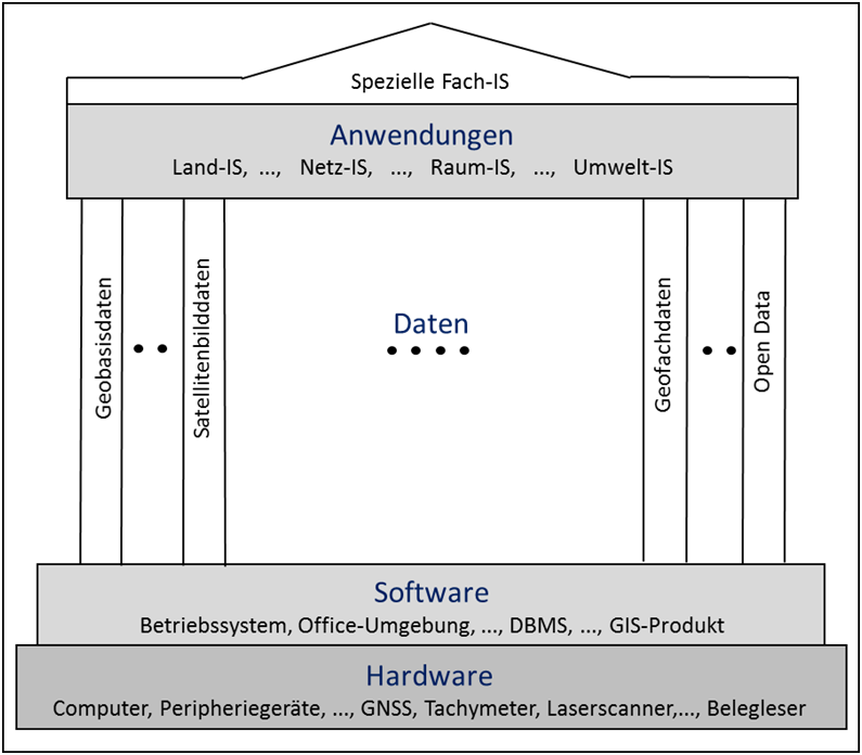
The hardware forms the foundation in GIS. These include the workstation computer, the network, the servers, peripheral devices such as printers, plotters and digitizers, but increasingly also devices that are used in the field such as surveying instruments - e.g. satellite-based surveying techniques using GNSS (Global Navigation Satellite System) - or smartphones with which citizens can be both users and producers of geoinformation. In recent years, there has also been a large number of sensors with which environmental conditions can be continuously recorded.
The software represents the stairway steps with which it is possible to climb the temple, i.e. to incorporate data into the GIS and to process applications with the GIS. The software includes the operating system, the office environment, the Internet, the database system and the GIS products with their various modules/trays.
The columns of the temple, on the other hand, are usually already one of the showpieces of our temple, they come in a variety of styles and carry the frieze and the roof. The columns of our applications are the data, specifically the geodata: Basic geodata - landscape models, orthophotos calculated from aerial photographs, satellite images, digital terrain and surface models - as well as a multitude of geodata, sensor data or data collected by volunteers (Volunteered Geographic Information (VGI), Citizen Science) together form the large geodata fund. They represent the raw material from which the GIS applications are fed.
The decorated friezes and the roof construction span the column construction of our temple. At this point in the GIS are the various applications, ranging from the construction of the necessary basic information, e.g. on land ownership conditions or topographic data collections (so-called land information systems (LIS), e.g. currently the AAA project in Germany (AFIS-ALKIS-ATKIS)), to a large number of GIS in specific application areas (e.g. network information systems (NIS) for supply and disposal companies, spatial information systems (RIS) for official statistics, spatial planning and state planning, environmental information systems (UIS) for environmental authorities or in companies) up to a large number of very special specialist information systems (FIS), e.g. in the tourism sector.
