Introduction and motivation
Land is a limited natural resource. The efficient allocation and intensity of use of land can only ensure our livelihood support and environmental protection (GLTN, 2018). In particular, the physical development has to be carried-out with special care in case of the new land consumption. For example, the national climate protection plan of Germany aims to achieve the Net Zero Target for land consumption by 2050 (Meinel et al., 2017). A sustainable settlement development (i.e. low land consumption, greening of cities, avoidance of urban sprawl by priortising inner development before outer) requires more accurate as well as small-scale information on spatial features such as: land use, buildings and transport infrastructure.
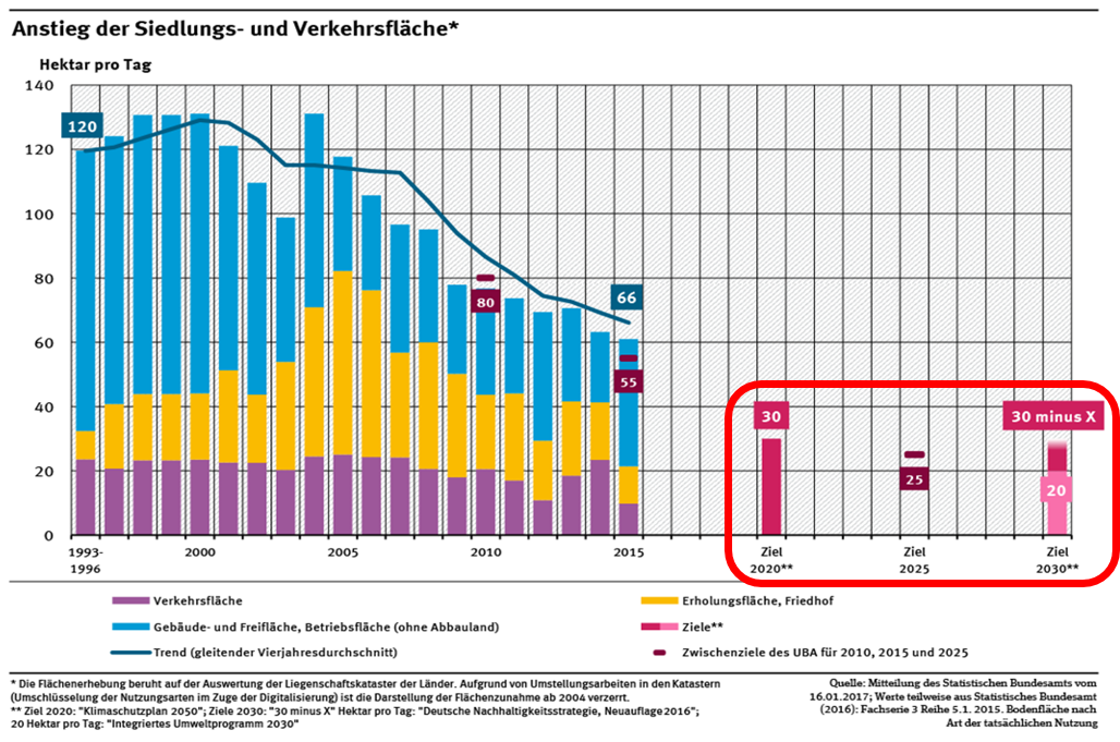
Basic data und diagram (as Excel) and more discussion can be followed by: Umweltbundesamt - Landuse for settlements and transport purpose
The diagram shows the increasing amount of landuse consumption for settlement and transportation purpose (hector/day) by comparing with the recreational land use, as well as the federal government's goals for land use reduction per year. Therefore, the spatial monitoring and evaluation of settlement development at the best possible small-scale are one of the fundamental tasks in order to meet the requirements of politics and society for examining and achieving such environmental goals.
The importance of this task is also reflected in the contemporay literature:
Zum Beispiel:
„Staat, Gesellschaft, Wissenschaft und Wirtschaft benötigen eine leistungsfähige Raumbeobachtung, die Entscheidungsträgern und Interessierten Informationen zu demografischen, ökonomischen, sozialen sowie siedlungs- und infrastrukturellen Zuständen und Entwicklungen bereitstellt“ (Siedentop & Kaup, 2017; p. 3).
