Spatial distribution of biogenic resources
Let's go back to the key questions asked at the beginning:
- What quantities of biogenic resources can we use sustainably?
- Where are the resources?
- What contribution can biomass make towards the transformation of energy systems (or towards the bioeconomy in general)?
In the previous chapters, you have already acquired knowledge about the available and exploited potential of renewable raw materials and biogenic residues and waste materials in Germany. This information focuses on the national level. However, biogenic resources are differently spatially distributed. The economic use of biogenic resources therefore requires intelligent and biomass-specific supply concepts. Especially for the mobilisation of unused biomass potentials from residues and waste materials or for the optimisation of already established material flows, the location of a biomass accumulation is an important key information. Due to low energy densities, the transport value and thus the maximum transport distance of many biogenic residues and waste materials is limited. At the same time, bioenergy plants require minimum quantities in order to operate economically and ecologically.
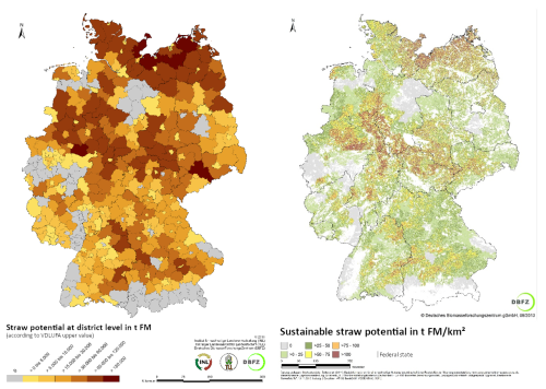
By linking open data sets (geodata, statistics, specialist data), potential information can be processed with the aid of geo-information systems (GIS) in such a way that preferential regions or locations (from the raw material point of view) for certain bioenergy plants can be identified. Depending on the issue at hand, this can be done at the level of administrative units (e.g. federal states, districts, municipalities) or independently of administrative structures (km², arable land). The figure shows the cereal straw potential for Germany at district level and by km².
Cereal straw potentials at district and km² level, Source: Brosowski 2014
Compare the two maps. Which statement on straw potentials can you make? What influence does the spatial reference have on the significance of the maps?
In preparation for the exercises, consider which open geodata sets and statistics you know and whether these could be suitable for the spatial presentation of biomass potentials.
In the following example, the technical potential of the biomass "cereal straw" is determined. Use this example and the information from the previous chapters to start thinking about how you can present biomass potentials with geodata.
