Sentinel-2, part 2
The direct comparison of Sentinel-2 and a very high-resolution aerial photograph, being availabe in Germany as Digital Orthophotos (DOP-20/40) in ATKIS, illustrates very clearly the differences in the recognizability of objects:
Task: Arrange the following examples of different spatial resolutions in remote sensing and sort them from low (left) to hoght (right) resolution:
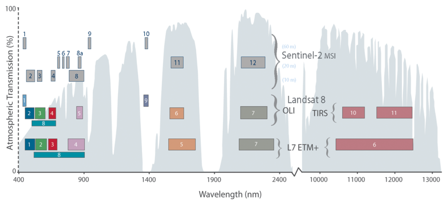
The spectral resolution and the individual channels of Sentinel-2 are shown in the following figure in comparison to the coverage of Landsat 8 and Landsat 7.
The spectral bands of Sentinel-2 MSI (Multi Spectral Instrument) compared to Landsat 8 OLI (Operational Land Imager) & TRS (Thermal Infrared Sensor) and Landsat 7 ETM+ (Enhanced Thematic Mapper). The background shows the permeability of the atmosphere (including the atmospheric window). Source: NASA
The Sentinel-2 bands are shown in the following figure (Reflectance curves from Kokaly et al. 2017).
Task: Spectral bands: Click on the white crosses highlighted in blue:
As with other remote sensing sensors, the individual bands are also available as gray value images. In the case of Sentinel-2, these are stored with a radiometric resolution of 12-bit, which corresponds to a contrast capability of 212 (i.e. 4069) gray values.
Here we refer again to the Sentinel Playground.
With the following image slider you can see what the gray value images of the individual channels of Sentinel-2 look like. The first image is an RGB normal color composite. A small gimmick: A passenger plane that flies through the scene can be clearly seen. Due to the movement of the airplane and satellite, but also due to the way the scanner works, the bright object appears separated in the almost maximum RGB colours.
The grayscale images can be combined as required (three by default, RGB). Thus different image areas can be addressed according to intention and need.
Task: Properties of various remote sensing sensors: Use drag & drop to assign the names of the sensors to the small squares within the coordinate system according to their properties.
